Wilderness Park Master Plan

Overview

LPR-WildernessPark-6.jpgIn 2020/21 the City of Lincoln, Parks and Recreation Department, conducted an update of the Wilderness Park Master Plan to review improvements to the user experience elements. During this process, guidance was sought from the Wilderness Park Master Plan Working Group as well as the general public.

The primary goal of this project was the development of an annotated map to serve as a master plan for Wilderness Park that identifies user experience amenities and guides future improvements associated with the park’s trails, trail heads, wayfinding signage, parking lots, etc. This plan was adopted by the Parks and Recreation Advisory Board in April of 2021.

Master Plan Goals

The 2020 User Experience Master Plan takes into consideration the plans of the past in the light of today’s conditions and the desires expressed by the users of Wilderness Park.

Wilderness Park Planning Through the Years

The plan itself is meant to address the “user experience” in the park – the experience of the park visitor as they enter the park, what they see as they move through the park, the trails, signage, and stream crossings they encounter. The goals below are meant to reflect input received through several recent outreach efforts and to be general and overarching in nature. The improvements that result from this effort are meant to be accomplished over a period of time, some longer than others, and as funding is available both to construct them and to maintain them into the future.

Provide a user experience that allows visitors to explore wilderness.

This is probably the longest standing goal for Wilderness Park. Wilderness Park is different from most of the other parks in Lincoln and Lancaster County in that it is mostly left to management by natural processes and the trailheads and trails and a couple other small areas are the only places where active management occurs. While most of Wilderness Park is not true “wilderness”, there are many areas with unique and important habitat, and the park serves as a reservoir for many species that may not otherwise be able to thrive in an urban environment. This goal also reflects the desires expressed by participants in recent public outreach efforts who strongly favored the protection of the natural environment, minimization of any signage or other “man-made” improvements, keeping the trails within the park rather than diverting to adjacent roads or trails, and reducing the views and sounds of nearby urban uses as much as possible.


Increase trail route options available to all users with minimal increase to the overall miles of trail.

The trail was originally developed with hiking and horse trails, with bike trails being added later as biking became more popular in the community. While the trails are designated by user, the signage and designation is not always adhered to by all users. However, as one representative on the Working Group once said (paraphrasing) “people don’t stray onto other trails because they’re bad people and they want to break the rules. They do it because they love Wilderness Park and they want to be able to experience more of it.” Carefully examining the trails to see where opportunities might exist to expand user options and thinking about the impacts, both to comfort and safety, but also to any needed improvements to accommodate users, may reveal opportunities to expand the miles of trail open to each user group, while not actually building significant new miles of trails. This goal is reflected in such recent support for consideration of “all-user” trails in some or all of the park, making more connections between trails, maintaining the north/south connectivity of the trail system, and making sure the natural environment is impacted as little as possible with new projects.


Locate and select capital improvements that provide sustainable access and prioritize protection of natural resources.

“Sustainability” has many different implications, but at its core it’s the consideration of the long-term implications of a decision. What will the consequences be for the natural environment? Is the location one where it can be reasonably expected to remain for the long term? Is the improvement one that can be maintained with the resources available? In Wilderness Park, these decisions must be made within a constantly shifting natural environment. Protection of natural was strongly support in several different public input activities, and ongoing utility and maintenance of features is important to both users and the City.


Provide signage that assists in navigation, improves the understanding of park rules and etiquette, and communicates the importance of Wilderness Park to the community.

Signage in Wilderness Park should be different from signage in other parks or along other trails. In order to fulfill the first Goal of providing a Wilderness experience, signage should be minimal and unobtrusive, but there is still a need to provide some information to users within the park. Signage can also help to increase awareness and educate visitors to the park on the history, importance, and inhabitants of Wilderness Park. Signage can assist in the navigation of the park and provide locational information should emergency services be required. Signage is one of the most frequently mentioned improvements desired in the park.


Provide trailheads that are safe, welcoming and provide useful information and services to park visitors.

Trailheads are an opportunity to orient park visitors to the space, deliver important information and provide the “first impression” of the park. Trailheads that are clean, well surfaced, and have typical amenities such as trash cans, signage, seating, mounting blocks and hitching posts set visitors off on their journey on the right foot. Trailheads should also feel safe and have information such as contacts in case of emergency or concerns. In some cases trailheads may be able to have enhancements such as space for seasonal porta-potties, grills, picnic tables and other facilities.


Master Plan Project List

Download to print the Wilderness Park Master Plan(PDF, 15MB)

Masterplan Project Details

The list of projects was developed over an eight-month period using public input as well as contributions by the 11-member Wilderness Park Master Plan Working Group.

Project 1: - Phase 2 of Trailhead Improvements

Phase 1: is currently funded and underway.

Total- $102,975  (Asphalt-$4,500, Rock- $61,425, Bollards- $37,050)

Phase 2: Trailhead Improvements

  1. Replace deteriorating and missing bollards
  2. Seasonal portable restroom pad/enclosure. Only available outside floodplain
  3. Concrete pad for ADA parking
  4. Grading and rock in parking lots
  5. Solar Lights (programable)
  6. Add picnic tables

Total- $131,200 (Concrete- $35,000, RR Shelters- $30,000, Tables- $3,200, Lighting- $63,000)

Not funded.

WPMP-1Visual_Parking-Lots.jpg


Project 2 - Kiosks and Navigational Signage

Completed October 2021

Kiosks

  • 7 kiosks installed in phase 1 at trailhead/parking lots 1, 2, 3, 4, 5, 7, and 8.
  • The remaining kiosk will be installed at the West end of the GPTN Connector with the future trail extension into Wilderness Park.
Information Displayed on Kiosks:
  • Park Regulations
  • Trail Etiquette
  • Interpretative Stories
  • “You are Here”
  • Trail Alignments
  • Trail Mileage
  • Emergency Contact
  • Points of Interest
  • Park Boundary
  • Adjacent Trails/Roads/Railroads
  • Park Typography
  • Bridges/Low Water Crossings
  • Jamaica North Access Points
  • Waterways
  • Park Website
  • Approved User Groups
  • Known Hazards
  • Parking lots/Trailheads
  • Park Map
  • And Much More... 

The Trails:

The labyrinth of Wilderness Park trails are separated into three routes:

  1. “R”ed Square: All User Trail
  2. “G”reen Square: All User Trail
  3. “Y”ellow Square: Hike and Bike Only Trail

Wayfinding:

  • 5”x5”x8’ metal tube post with mounted wayfinding navigational signage will be placed at every park intersection and Jamaica North access points.
  • Each post will have a metal cap with a location number that reflects the numbers on the kiosk map. The post caps also brand the park.
  • Each post will include colored squares of the adjacent trails with a directional arrow directly next to it.
  • The posts closest to the parking areas/trailheads will have a “P” and arrow marker directing the user to park exits.
  • Maximum number of mounted signs per side of post = 8
  • 1” Spacing between mounted sign sets. Each set is a colored square/letter and a circle/arrow.
  • Font = “Parker” (customized stencil for metal cutout)
  • Reference arrows should be listed in the following order: Parking, JNT, Multiple Directional Arrow, Straight, Left, Right, Angled.

Total Estimated Cost: $48,000

Currently funded and underway

WPMP-2Visual_Kiosk.jpg


Project 3 - Fitness Loop

The Fitness Loop equipment located in the northern end of the park is beginning to fail and needs to be rehabilitated. There may be an opportunity to add or relocate features in the same general area. This project would replace existing equipment with similar materials, reuse some of the galvanized steel pieces that are in good conditions, and potentially relocate or add features to space the equipment out and create a full loop.

 Rebuild with similar features, adjusting some locations. Estimated Cost: $15,000 (2020 Dollars)

 WPMP-3Visual_FitnessLoop.jpg

Project 4 - Epworth Arch

This project would include masonry restoration work on Epworth Arch similar to images below on the as well as clearing overgrown vegetation to establish an inviting picnic space.

Total Estimated Cost: $35,000.00  (2020 Dollars)

WPMP-4Epworth_Arch.jpg

Project 5 - 1st Street Low Water Crossings

There are currently two low water crossing south of the 1st Street Trailhead; one that has been recently improved and one that has not. A single trail leads from the parking lot to a fork just before the low-water crossings and then the two trails reconverge at a point east of the two crossings. This project would improve the second crossing in a similar manner and improve the approaches to both crossings.

Total Estimated Total: $8,000.00 (2020 Dollars)

WPMP-51ST_LowWaterCrossing.jpg

Project 6 - Old Cheney Suspension Bridge

The suspension bridge located just south of the trailhead on Old Cheney Road is beginning to show signs of age. Regular inspections are conducted to insure it is still safe, but plans should be made for its eventual replacement. This project would replace the suspension bridge with a design that respects the character of the old suspension bridge, but meets current safety standards.

Replace with pedestrian bridge that reflects the character of the current bridge.

Estimated Cost: $425,000 (2020 Dollars)

WPMP-6OldCheneySuspensionBridge.jpg

Project 7 - Rock Island RR Embankment / GPTN Connector Area

Rock Island/ GPTN Connector

In 2019 a bridge just south of the old Rock Island RR embankment failed and was removed. The stream channel at this site is showing signs of instability which make this a difficult location for a replacement. In 2020 the new GPTN Connector bridge was completed, creating a new entry point into Wilderness Park which lead to a dramatic increase in use of this area. The following projects would address connectivity both north/south and east/west in this area. These could be completed in phases as funding is available or concurrently in a single project.

Trail Reroute

Create ramps onto the Rock Island embankment, avoiding pinch point along streambank. Open railing at ramp from GPTN Connector to allow access to the ramp crossing. Continue to join Jamaica North for crossing tributary, but this would shorten distance on Jamaica North.

Estimated Total: $5,000.00 (2020 Dollars)
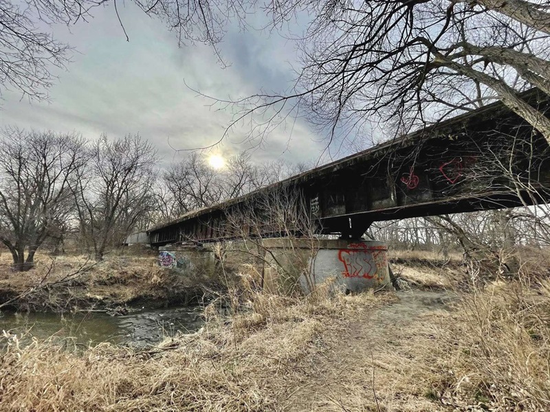
 WPMP-7RockIslandRR.jpg

Salt Creek Bridge

Project funded. Estimate 2023 construction.

Continue trail along Rock Island embankment to bridge over Salt Creek. Rehab bridge with railing and decking if needed. This will connect the east and west sides of the park.

Estimated Total: $275,000.00 (2020 Dollars)

Hinterland Bridge

Relocate bridge that was removed to a point upstream where stream banks are more stable. This will reconnect Wilderness Park trails to remain within the park. 

Estimated Total: $300,000.00 (2020 Dollars)

Total Estimated Cost: $580,000.00 (2020 Dollars)

Project 8 - Cardwell Low-Water Crossing

There is currently a low water crossing on Cardwell Branch, approximately ½ mile south of Warlick Blvd. Rock in the bottom of the creek crossing frequently washes out and the approach ramps are steep and prone to erosion. This project would install culverts in Cardwell branch to allow for crossing of trail users and maintenance equipment and reduce erosion issues along approaches.

Total Estimated Cost - $125,000 (2020 Dollars)

WPMP-8CardwellCrossing.jpg

Project 9 - Rokeby and HWY 77 Bridge

This project will connect two trails that were formerly connected by accessing HWY 77 ROW, crossing a culvert, then continuing back into the park. The old section of trail was recently removed by order of NDOT, leaving a dead end loop. The City of Lincoln recently purchased the bridge pictured on the right and with some engineering, could be placed over the tributary to connect the two trails again.

Total Estimated Cost: $150,000.00 (2020 Dollars)

WPMP-9RokebyHWY77-bridge.jpg

Project 10 - Small Culvert Replacement

Completed March 2022

This project will replace a failed culvert just NW of the Saltillo Rd. Trailhead, establishing better drainage.

Estimated Cost: $15,000.00 (2020 dollars)

WPMP-10SmallCulvert-Map.jpg


Master Plan Background Information

Wilderness Park Master Plans

Supporting Information


Wilderness Park Stream Crossings

The community has been invited to provide input on priorities for repair/replacement of stream crossings. Parks and Recreation staff will use the new guidelines to evaluate options for future stream crossings with an emphasis on maintaining connectivity of trails throughout the seven-mile-long park. Stream crossing structures in Wilderness Park include small pedestrian bridges, larger multi-use bridges and low water crossings. All of the bridges are regularly inspected for safety, and structures deemed unsafe are closed until it is determined whether to repair, remove or replace them.

November 21st, 2019
6:30 to 8 p.m.
Woods Park Place, 3131 "O" St., lower level training center

January 23, 2020
6:30 to 8 p.m.
Woods Park Place, 3131 "O" St., lower level training center


 Wilderness Park Master Plan Working Group:

  • Adam Hintz
  • Anna Wishart
  • Chris Heinrich
  • Dan King
  • Jim Crook
  • Joeth Zucco
  • Kat Baum
  • Matt Gersib
  • Rosina Paolini
  • Susan Larson-Rodenburg